|
Here are answers to
some of the questions I get asked most frequently regarding the Edwards
Aquifer and issues surrounding it. Let me know if you have
a question you would like to see answered here.
- Unless we start mining the resource by
using more than goes in on a long term basis, we will
always be able to get plenty of good water for critical
uses like eating and bathing. We have never seen the
Aquifer less than 90-95% full, so there is lots of water
down there we can use if we have to in an extreme
drought. However, we sometimes DO run out of water in the
top 5-10% of the Edwards formation, and when that happens
the springs stop flowing. Lots of people, along with
endangered plants and animals, depend on water from the springs. To keep them flowing we have to keep the
Aquifer almost full.
Maybe it's more correct to call it a money shortage. If money were no object, we could do very expensive things
like desalinate
ocean water and have an unlimited supply. What we are
running short on is the cheap, seemingly limitless
aquifer water that we have been used to using without
restriction. All of the alternative water sources seem
very expensive by comparison.
Yes.
Because of the complexity of the
Aquifer system, it is difficult to narrow down the range
of how much water we think it contains. One
thing that is clear is there's a big difference between
how much water the Aquifer contains and how much water
could be extracted. Some researchers have estimated the Aquifer may contain as much as 175 million acre feet. However, that figure includes water locked up in pore
spaces that are not connected to any other pores, so that
water can't move anywhere and is therefore not available. A more reasonable estimate of 25-55 million acre-feet is
based on effective porosity, which is a measure of the
percentage of pore spaces within the rock that are
connected to other pore spaces (see
Maclay, 1981 and
Ogden, 1986). Pores must be connected for water
to move through the rock and to the surface through
springs and wells. One should not think of the Aquifer as a vast underground pool. Rather, think of it as a saturated sponge with pipes. The rock matrix has many pore spaces similar to the holes in a sponge, and some of them are connected by well defined conduits through which water can readily flow. Almost all the water storage occurs in the matrix, and almost all the water movement occurs in the conduits.
-
If there's
25-55 million acre feet of water available, and if we use
only 450,000 acre feet a year, then it sounds like
there's enough water to last more than 100 years! However, the aquifer
contains a lot of water that we can't
really get to in legal or practical terms. The
problem is the springs go dry when the aquifer is still
95% full. So as long as we are going to maintain at least
minimal natural springflows for the sake of endangered
species, recreational economies, downstream ecosystems,
and downstream economies, then the large amount of water
below the level of the springs is essentially unavailable
to us. Even if we did decide to let all the springs go
dry and pump out as much water as we need, it is very
expensive to pump large amounts of water up from great
depths and it would soon get prohibitively expensive.
One potential approach to managing and ensuring springflows has been dubbed "Recharge and Recirculation". It is a collection of water management strategies that would add enhanced recharge to the Edwards Aquifer and hold that enhanced recharge in aquifer storage until needed for water supply and for protection of springflows and downstream flows in critical times.-
- Proponents of springflow augmentation
suggest that if we can keep the springs flowing
artificially, endangered species would be protected and
we might be free to use the Aquifer more like a conventional water supply reservoir, which are drawn down during times of shortage and allowed to fill back up during wet times (see FAQ below).
-
- In 1995, McKinney
and Sharp were the first to study the
technical feasibility of augmenting springflows and
concluded that artificial supplementation could provide
protection in times of drought for federally protected
species, but a lot of unknowns still existed.
-
- The 1995 study looked at injecting
water into the Aquifer near the springs, enhancing local
and regional recharge, and direct addition to the surface
at the spring openings. Sharp said further studies could
answer a lot of unknowns, such as specific flow paths to
the springs and whether any of the aquatic species
require water to be flowing from the spring orifices.
-
- Other
analysts were concerned that augmentation might be
prohibitively expensive and that systems to deliver water
to the springs might provide little or no benefit when
needed most, during times of extended drought.
-
- The issue seemed worthy of further study, however, so work sponsored by several agencies was conducted.
There were two types of projects considered for providing enhanced recharge to the Edwards. Type I projects would involve an engineered structure placed on the Contributing Zone that would capture flows and hold them for release to the Recharge Zone. Type II projects would include an engineered structure placed directly on the Recharge Zone, and water would be held for direct infiltration. Potential sources of water were stormwater flows, unused Edwards permits that might be purchased or leased, and diversions from other regional rivers and streams. New firm yield water supply would come from issuance of recharge recovery rights and diminished critical period pumping reductions. Some of the additional water recharged would be recirculated by removing it through wells downgradient from where it recharged and pumping it back to recharge areas.
The first phase of the project involved using a model of the Edwards Aquifer prepared by the United States Geological Survey to evaluate feasibility. Two recharge scenarios were modeled, and both scenarios predicted long-term storage benefits of up to several years when 25,000 acre-feet were placed in the Aquifer.
A second phase involved using the same model to simulate aquifer responses to recharge at eight different locations. Numerous combinations of recharge timing, volume, and location were simulated. The simulations predicted that by introducing approximately 149,000 acre-feet of enhanced recharge and applying Critical Period Management rules, Comal Springs could be kept from going dry during a repeat of the 1950s drought of record.
The third phase of the project evaluated potentiial operational parameters, water sources, and costs for the various scenarios. The optimum placement of recirculation wells was determined based on factors like impact to springflows and length of recirculation pipelines. Potential water sources were also evaluated, such as diversions from the Guadalupe River and several area reservoirs.
When the recharge and recirculation option was analyzed by scientists and stakeholders for the Habitat Conservation Plan, they concluded it would not result in springflow levels that would be protective. Also, cost estimates were considered impractical, and there would be potential regulatory, technical, and political impediments to implementation.
When SAWS released a 2012 update to its Water Management Plan, it concluded that given the present regulatory environment and uncertainty in the scientific studies of the concept, SAWS would focus on water
supply projects with greater certainty.
All along, there was a contingent of biologists and scientists who were adamantly opposed to Recharge and Recirculation as an Edwards management strategy. They insist such schemes will negatively impact critical spring habitats and fail to ensure adequate species protection and recovery from low-flow events.
In any case, with the conclusions made in the Habitat Conservation Plan and with SAWS focusing on other alternatives, the idea seems off the table for now.
We could be doing better. Protecting water quality is the big upcoming issue that will need to be dealt with over the next several decades. After more than 40 years of controversy and debate, we have not been able to implement truly effective regulations Aquifer-wide. The main tool available for Aquifer protection has turned out to be fee simple purchase of sensitive lands and conservation easements.
Users of the Edwards Aquifer are lucky
because no major water quality or pollution problems have been experienced
YET. In San Antonio there is little heavy industry and not much
potential for serious degradation. Although there is a Superfund site in Leon Valley and there have been other isolated instances of pollution, we have not yet experienced any widespread problems. Currently, Edwards water does not require treatment before distribution, other than disinfection by chlorination.
To keep the water clean for
future generations, however, vigilance in protecting the Recharge and
Contributing Zones
will be necessary. Once water in the Aquifer becomes contaminated,
it will be very difficult and perhaps impossible to clean.
The only alternative might be to treat water by conventional means
after it is pumped to the surface, an expensive proposition that most
cities other than San Antonio have already had to invest in. In most
cities, water is drawn from a river or reservoir, treated in a central
location, and sent to customers over a wide area through very large
distribution mains. In San Antonio, there are many Edwards wells all
over the city where water is pumped out, stored in tanks, and distributed
mainly to the local area. There are no large conveyance systems and there
would be no way to move large amounts of water from a central treatment
facility if it became necessary. Instead, there would probably have
to be a large number of smaller treatment facilities located close to pumping centers, which would be more expensive to build and operate. If it became necessary, the cost for
treating Edwards water would be a very big number indeed. Whatever
that number is, that is the value of the treatment the Aquifer is
currently providing for free.
The first rules to protect the Edwards were issued by the Texas Water Development Board in 1970. Since then, the TCEQ and the EAA have also developed rules. Most observers agree all the existing rules are woefully weak and inadequate. In 1995, San Antonio enacted its first rules and guidelines for
development over the Recharge Zone. But developers had plenty of heads-up time and were grandfathered to develop in the old fashion as long as they filed a plat before the rules went into effect. The result was that large sensitive areas in northwest Bexar county were developed without meaningful protections. In any case, only 2% of the Recharge Zone is
within San Antonio's jurisdiction, so more widespread requirements for
ecologically sound development are needed. It is also important that
people living and working on the Recharge Zone be aware of how the Aquifer can become
polluted and refrain from dumping used motor oil, cleaning agents, and
other common household chemicals.
Since there is a well-established scientific link between development and runoff water quality, Edwards water quality protection mainly comes down to managing growth and limiting impervious cover. Protecting the Recharge Zone is not enough. It is just as important to
protect the quality of water that runs off the Edwards Plateau and ends up
as recharge, but Contributing Zone controls receive much less attention. Builders can do almost whatever they like on sensitive properties adjacent to the Recharge Zone (see photo on Hydrogeology page).
Contributing Zone protections are hugely complicated by the fact that people living on the Edwards Plateau are not Edwards Aquifer
users. They do not readily accept the notion of restricting their area's development and implementing rules for the sake of other people's water supply, especially since they perceive that Edwards users have not been especially proactive in managing development over their own Recharge Zone. There is growing evidence that protecting the Contributing Zone is also important because of the hydraulic connections between the Edwards and the Trinity. They are more significant than previously believed, but this is not reflected in current TCEQ rules. See a presentation by Dr. Ron Green on the hydraulic relationship between the Trinity and the Edwards.
Meanwhile, there are also significant cultural obstacles to effective water quality management. Texas is a state that is very respectful of private property rights, and many will simply not accept the notion that land use and development should be regulated. On the other hand, a growing number of people don't believe anyone has a private property right to ruin common resources like air and water. However, powerful development interests usually get their way, and so far no lawmakers have been willing or able to take a big-picture view and develop a comprehensive water quality management approach for the Edwards. Texas must eventually find a balance between private property rights and protection of common natural resources.
At present, there is simply no institutional or regulatory framework that can effectively protect Edwards water quality. Most of the Edwards Plateau is not within the jurisdictional boundaries of the Edwards Aquifer Authority, and an expansion seems unlikely. Although the enabling legislation of the EAA seems to authorize that agency to implement water quality rules, the legislation's author has said it does not. The issue was hotly debated in the 2003 and 2007 legislative sessions and no resolution was reached. The EAA has several times delayed development of water quality rules because it was concerned such action would result in a private property rights backlash and legislative retaliation. Many contend the Texas Commission on Environmental Quality is the proper agency to regulate for water quality, but so far that agency has not been especially proactive in developing water quality controls, and like the EAA, the TCEQ's authority to apply rules to the Edwards does not extend to most of the Contributing Zone.
In addition to cultural and institutional obstacles, the roots of our inaction on Aquifer protection also derive from the mindset of water managers and business leaders of a generation ago. In 1982, local officials strongly opposed the Sole Source Aquifer Protection Act, a federal bill that would have provided 50% federal funding for development of aquifer management protection plans and purchase of recharge zones of sole source aquifers. The bill was sponsored primarily by New York state representatives for the purpose of allowing the residents of Long Island to purchase the recharge zone of their aquifer, but provisions would have allowed residents of any designated sole source aquifer area to request financial assistance from the US EPA (the Edwards was the first aquifer to be designated as Sole Source). The directors of the Edwards Underground Water District said the bill would be contradictory to the Reagan Administration's policies of returning more responsibility for local matters to the state and local governments (Federal funding for New York aquifer opposed here, San Antonio Light, May 7, 1982). EUWD manager Tom Fox said Edwards Aquifer management "has been adequately addressed by the state and local governments" (Directors of EUWD opposing Aquifer Protection Act of 1982, Northeast Herald-News, May 20, 1982). The North San Antonio Chamber of Commerce also opposed the proposed law, saying it would result in only "a further expansion of the federal budget with little or no significant improvement to the environment" (Edwards Aquifer controls opposed, San Antonio Light, July 30, 1982).
As mentioned at the beginning of this FAQ, we have not been able to get where we need to be through regulation, the only real tool available has turned out to be simply buying sensitive land and conservation easements. Toward that end, San Antonians have consistently demonstrated their support for Aquifer protection by taxing themselves to raise money for that purpose. In May of 2000, voters approved a 1/8 cent sales tax to raise $45 million to fund purchases of undeveloped land in the Edwards recharge zone. In 2005, voters extended the tax to collect an additional $90 million and also approved a measure to purchase land along creeks to build linear parks. In 2010, voters approved the tax for a third time to generate an additional $90 million. So far (2015), revenues from the sales tax have resulted in the protection of more than 125,000 acres, either through outright purchase or through conservation easements. In May of 2015, voters re-authorized the tax for a fourth time by the widest margins ever, once again demonstrating that San Antonians are committed to Aquifer protection.
For background info and a more complete discussion of the water quality issue, see the Laws and Regs Page.
-
Proponents of managing the aquifer as a
reservoir suggest there are many ways we could use the Aquifer to a
greater extent in dry times, and then let it fill back up when the rains
come. This is certainly the approach that water managers
use to get the maximum benefit from a surface water
reservoir. Such an approach could involve recirculation and/or
augmentation systems to keep the springs flowing. A number of
studies are underway regarding Aquifer optimization, and many are focused
on gaining a better understanding of the flowpaths and discrete units or
"pools" within the Aquifer. -
- It might be possible, for example, to draw more water
from particular units while leaving springflows largely unaffected.
Or it might be possible to bring water from behind the "Knippa
Gap", which is a narrow opening within an extensive, complex system
of barrier faults and a major controller of flow within the Aquifer.
Huge amounts of water cannot pass quickly through the Gap, so water piles
up in storage units behind it, causing water levels in wells to the west
to display much less variability than wells to the east. Water that
recharges in western Medina and Uvalde counties has to flow through the
gap to reach the main freshwater zones in Medina and Bexar counties. There is significant opposition to the idea of bringing large amounts of water from behind the Gap. Whenever the idea gets discussed at public meetings, residents in Medina and Uvalde county come out with torches and pitchforks in oppositon (see the FAQ below on the Knippa Gap).
-
- In addition, many questions are unanswered. For example, there is
no evidence to suggest that recharge will be increased
during rainy times simply because we have drawn the level
down low in dry times. The recharge conduits are fixed in
size and may not be able to recharge the same volume of
water drawn out.
-
Though many questions and issues exist, there is
indeed some potential to build a few Type II recharge dams in addition to the
ones that already exist. They
would not be a magic-bullet type of solution and could only supply a small
percentage of overall projected water needs. The draft plan of the
South Central Texas Regional Water Planning
Group estimates an average of 21,000 acre-feet per year could be added to
the Aquifer. In short term droughts additional
recharge could help get us over the hump, but recharge dams
can't help in a long term drought because there will be
no water to recharge. The Edwards is not a good storage
aquifer where water stays put for use tomorrow. As long
as enough hydraulic pressure exists to force water up of
the level of springs, significant amounts of water will
flow out. In a 3-5 year drought, all the water that was
recharged during wet times will have left the Aquifer. And there
are some thorny issues involved, such as the fact that Type II dams are
constructed on the recharge zone which is the most environmentally
sensitive area. Also, most people don't want their land to be
sacrificed for such projects, but somebody's would have to be. Further, it is unclear who would pay and who
would benefit. For more on recharge dams, such as what the
difference is between Type I and Type II dams, see the section on
Edwards
Alternatives.
-
The idea behind "Western" water is that large water supplies could be piped towards San Antonio from Edwards Aquifer pools west of the Knippa Gap without having much impact on the J-17 index well in San Antonio or flows at Comal and San Marcos springs, thereby protecting endangered species and their habitats. At the Knippa Gap in central Uvalde county, there is a structural constriction in the Edwards and a great deal of focused recharge from the Frio and Dry Frio Rivers. The combined effect is a damming of groundwater upgradient and to the west of the Gap. Large amounts of water cannot pass quickly through the Gap, so water piles up in storage units behind it, causing water levels in wells to the west to be much higher and display much less variability than wells to the east (see the Knipp Gap graphic).
Several different proposals were developed that would bring water from either Uvalde or Kinney and Val Verde counties. Some of the water marketers exploring projects included former Governor Dolph Briscoe and former state Senator Buster Brown, who said they own or have access to 60,000 acre-feet of Edwards water rights. Pumpers in Uvalde county are regulated by the Edwards Aquifer Authority, while the Kinney/Val Verde section of the Edwards is hydrogeologically separated from the portion that serves San Antonio and is not subject to regulation. So in the Kinney/Val Verde area, there would be little to stop water moguls from pumping and exporting water except economic infeasibility, and residents with torches and pitchforks. Uvalde county is closer, so a shorter and cheaper pipeline would suffice, but a portion of the 1993 law that created the EAA banned pipelines from the area.
For any project to work, the area's largest water purveyor, the San Antonio Water System, would have to be a customer. There is intense local opposition in cities west of the Gap to exporting water to San Antonio, and efforts to reverse the Uvalde pipeline ban were defeated in the last four legislative sessions.
Although water experts have been talking about it for a long time, the issue first came to the public's attention in early 2004. A public debate erupted after Mayor Ed Garza held a private meeting with business officials who were highly critical of SAWS' leadership and questioned the utility's ability to adequately and economically meet the city's future water needs. SAWS leaders fell under intense pressure from water marketers and business interests to consider purchasing western water.
-
In order to give the public some assurance that all parties were taking an unbiased look at the concept, SAWS had the University of Texas conduct a study using a new Edwards model. It suggested that pumping 40,000 acre-feet per year from the Edwards in Uvalde county would lower well levels and triple the amount of time Uvalde residents spend in drought restrictions. It would also drop J-17 levels in San Antonio by four feet, thereby increasing the duration and severity of drought restrictions in San Antonio as well. SAWS Board Chairman James Mayor said "I just don't think it would be the right thing to do." In a commentary published by the San Antonio Express-News, Mr. Mayor said SAWS' policy is that water supply projects will be designed to produce the greatest benefit for San Antonio, the Edwards region, and partnering communities, not the "greatest good for a few". Although acquiring additional Edwards rights may be the cheapest option, Chairman Mayor said SAWS' policy is it will only buy Edwards rights in quantities that do not disrupt another community's economy. The Express-News also published a comment by Joe G. Moore, Jr., who served as court monitor for federal judge Lucius Bunton and was a central figure in the Sierra Club v. Babbitt case that resulted in pumping limitations for Edwards users. Moore said that so far, SAWS had been doing exactly what the federal court expected San Antonio to do in seeking water sources other than the Edwards. He warned that if SAWS is forced by business or political interests to purchase more Edwards water instead, it would be like putting all of the city's eggs back in one basket, a major mistake the city has made before.
Since then, leadership at SAWS has changed several times, and Joe G. Moore has passed away. New leaders at SAWS say they had not closed the door on the idea, but neither was it on the front burner. There would be many significant obstacles that would make the project risky for investors, including overcoming local opposition, undoing the pipeline ban, securing water rights, and obtaining complicated permits.
In 2006, a new evaluation of the Edwards Aquifer in Kinney and Uvalde counties by Ron Green and others concluded that a large area underneath Kinney county deserves designation as a separate pool. Previously, the area was believed to be a portion of the Uvalde pool. Green's findings may eventually have large implications for management and regulation of the Edwards and for water supply schemes to bring water towards San Antonio from west of the Gap.
By late 2008, tight credit markets and the country's uncertain financial future seemed to reduce the likelihood that any western Edwards water projects would be on the immediate horizon.
In March of 2009, the board of the EAA was advised by chief technical officer Geary Schindel that a consultant's report on bringing western Edwards water to San Antonio contained factual errors and technical shortcomings that �bring into question the validity of the analyses�. The proposal was offered by Southwest Texas Water Resources LP , who commissioned Pape-Dawson Engineers to evaluate the technical merits and the potential effects on the Edwards. The EAA staff found, among other problems, that the engineering report failed to consider the impact of a recurrence of a drought as severe as the 1950s drought of record. The report itself was not made public at first, and then only a heavily redacted version was released.
In July of 2010 the Uvalde City Council heard a presentation from Southwest Texas Water Resources, which was expected to seek a narrow exemption from the law banning pipelines from the area. Afterwards, the Council passed a unanimous resolution opposing such a change in the law. So far, proponents have not been successful at changing state law to allow bringing water east from behind the Gap.
In 2011, SAWS issued a formal request for proposals for new water supply projects that could provide an alternative water source and help diversify the city’s long-term water supplies. Nine proposals were received and in April 2012 SAWS narrowed the list of projects under consideration to four. A western Edwards pipeline was not among them, and Southwest Texas Water Resources LP announced that it had “ceased working” on its project. So without a customer, the idea of a western Edwards pipeline appears to be off the table for the foreseeable future.
The U.S. Fish & Wildlife Service
includes the possibly of salt water intrusion into the
fresh water zone among the reasons that some species have
been listed as endangered, but I have never talked to a
hydrologist who felt that saline water intrusion was
anything to be even remotely concerned about. During dry
times or when the Aquifer is drawn down to low levels,
very small volumes of salt water might intrude along the
interface between the fresh and saline sections of the
aquifer, but the saline water would be flushed back out
again quickly when water levels rose. A study by
Ewing and
Wilbert, 1991 concluded
that water quality deterioration, in all cases except
actual ground-water mining, would be temporary and
limited largely due to the significant difference in
permeability between the fresh and saline sections of the
aquifer and to the flushing action that would occur with
renewed increase in recharge. The reason the water is
saline to begin with is because the rock in that area is
much less permeable, so water moves slowly and stays in
contact with the rock for a long time. Because the saline
water is tied up in the rock, it will be difficult for it
to move from that area. Also, the saline zone lies
downhill from the fresh water zone, and it seems very
unlikely that salt water would suddenly start to run
uphill toward the fresh water zone. Additionally, salt
water is more dense than fresh water, so it tends to sink
below fresh water and the two do not readily mix.
The fresh water / saline
water interface, usually known as the "bad water line" is the
convergence of two flow systems within the Aquifer. It is actually a
zone and not a line. The freshwater area is generally updip, closer
to the land surface; while the saline water area is farther downdip,
deeper underground. In the freshwater portion of the Aquifer,
the limestone is highly permeable and transmission rates are high, so
water moves through it relatively quickly. By contrast, deeper down
in the formation, the saline water portion of the Aquifer has low
transmission rates and much higher residence times. When water is in
contact with limestone, it continually dissolves mineral solids from the
surrounding rock matrix. Eventually, the concentration of total
dissolved solids (TDS) becomes greater
than about 1000 ppm, and the water is
considered saline and not drinkable
(seawater is about 33,000 ppm). The "bad water line" is a
natural phenomenon that occurs along the southern and eastern edges of the
fresh water zone where water has been in contact with limestone for a long
time. Since the rock in the saline water zone is less permeable and
does not transmit water as easily, the movement of water is slower.
As a result, water stays in contact with limestone longer and becomes more
saline.
Because the movement of water
in the Aquifer is highly complex, the waters we pump from the ground and
drink are a mixture of waters of many different ages. In some places
water moves only a few feet a day, but in other places water may move 1,000
feet a day or more (Maclay, 1981 and Ogden, 1986). Some of the water we drink today is very old, but some went underground just recently. It can spend up to several hundred years underground before it emerges at a well or a spring, so some of the water being used today
likely went underground around the time that Texas was struggling to gain independence from Mexico.
-
- In 2011, researchers estimated that water pumped from a public supply wellfield on Wurzbach Road near Loop 410 had an average age of about 4 years, and some of it was up to 342 years old (Eberts, 2011). The large proportion of young water in this wellfield points up the need for protection of recharge water quality. The Aquifer has a tremendous capacity to stabilize organic wastes and other pollutants; in fact, San Antonio is the only major city in the world that does not have to treat water before distribution. But in some places the water may not stay underground long enough for the natural treatment processes to proceed, and the ability of the system to purify water may be overwhelmed or disrupted by excessive inflows of pollutants.
Average annual recharge for the period 1934-2023 is
about 683,000 acre feet. However, averages do not mean that
much in this region...recharge is highly variable from
year to year
(see recharge chart).
Geologists have noted that most of the major Edwards springs are in the east. San Pedro, San Antonio, Comal, San Marcos, and Hueco Springs are all located in the eastern third of the Edwards region. In the east there are also many more caves, and the recharge zone is thin at the surface. Towards the west, the recharge zone is much wider, fewer caves have been found, and there are no springs approaching the magnitude of those in the east. Why is this?
C. M. Woodruff, Jr. and Patrick Abbott have explained the location of springs and the evolution of regional Edwards circulation systems in terms of stream piracy and development in two diverse time periods. See the complete story and some graphics explaining the process on the Hydrogeology page.
The Edwards provides treatment that would otherwise cost us billions
of dollars. Whether or not it is a filter depends on which
definition you like.
According to Webster's dictionary, a filter is
"a porous article or mass that serves as a medium for separating from a
liquid or gas passed through it matter held in suspension or dissolved
impurities or coloring matter." In
the field of water treatment, a filter is usually composed of paper or
sand, where pore spaces are small enough so that water will pass through
but small suspended particles will not. The Aquifer is not what people in the water resource field
traditionally think of as a filter. However,
there are many pore spaces within the Aquifer that are so small that
large suspended particles cannot pass through.In this sense, and according to a strict definition, the Aquifer is
indeed a filter and does provide some filtration. -
- Regardless of what one thinks is a filter, there's one thing for sure:
the Aquifer transforms dirty brown polluted recharge
water into crystal clear spring water and well water that we safely drink
without any additional treatment. The same processes used by a
conventional wastewater treatment plant occur naturally in the Edwards. For more on water
quality, filtration, and treatment that occurs within the Aquifer, see the
section on
water quality
None. Well, it receives chlorination, and that's a treatment, but Edwards water does not require the kind of conventional treatment that costs most other cities millions every year. All surface water sources require treatment, as do many other groundwater sources, but Edwards water is drinkable straight from the ground. It wasn't drinkable when it went into the ground, so Aquifer protection is all about protecting the ability of the Edwards to naturally filter and cleanse stormwater runoff, so that we don't have to pay for it.
The limestones of the Edwards appear
to have sufficient bearing capacity so that subsidence
will not be a major problem. On the other hand, no one
really knows if underground caverns would collapse or if
flow patterns would change should the level be drawn
lower than ever before.
Right now it seems highly unlikely
that any more large surface water reservoirs will be
built. Environmental concerns would be many, and
landowners would fight tooth and nail against sacrificing
their beautiful river valleys to slake San Antonio's
thirst. Reservoirs eventually silt in and have to be
replaced, so in terms of a management scheme that will
last hundreds and thousands of years, reservoirs have limited value.
We probably won't be able to build ourselves a
solution with concrete and pipes, at least not a solution that uses
Edwards water. Many of the world's
best engineers and planners have been working on this
problem for a long time and if there were technical
solutions, they probably would have found them by now. Technology
can help a little, but the
solution lies in developing effective management
institutions and changing cultural attitudes toward the
value and use of water. There is certainly much potential for
using traditional technologies like pipes and treatment facilities to
bring in new water from elsewhere, but that's different than using
technology to augment or manage Edwards water. The basic issue is we
are already using all the water the Aquifer can make available and there
is only limited potential for making it yield any additional water on a
sustainable basis.
Regarding traditional structural solutions made of concrete and steel, two projects have been developed since 2000 that have been very successful in conserving Edwards water and maintaining springflows. One is San Antonio's recycled water distribution system, which has the capacity to replace up to 20% of the city's Edwards pumpage. See the section on using recycled water.
The second project is San Antonio's Twin Oaks Aquifer Storage and Recovery facility, which has the ability to store vast amounts of Edwards water during wet times and retrieve it during droughts. It has already been used successfully several times to defer Edwards pumping and maintain springflows. In 2010, a SAWS analyst uncovered a grievous error in calculations that consultants had made regarding the site's storage capacity. The actual capacity is far larger than consultants said it was, and in 2011 this discovery paved the way for Twin Oaks to become an important component of the Edwards Aquifer Recovery Implementation Program, a regional plan developed by stakeholders to protect the springs and endangered species habitat. For more on Twin Oaks, see the ASR page.
This one deserves its own section! See Brush
Management in the Edwards Alternatives section. -
No. Generally, confined aquifers do
not have water tables. The Edwards limestone is confined
between two relatively impermeable formations and is
always saturated; the only place where a water table
exists is near the recharge zone where there are no
overlying layers (see graphic in
Intro Section).
The "Aquifer level" reported
on the news has nothing to do with how far down it is
until you hit water in the main body of the Aquifer. It
is a measure of how much pressure is being exerted on
water in the formation at the location of the test well. When recharge enters the
Aquifer,
its weight exerts
pressure on water already inside. This pressure forces
water up through openings such as springs and wells. The
"Aquifer level" indicates the top of the water
surface in the test well, which is hundreds of
feet above the actual Edwards limestone. A good
"indicator well" is one that never becomes
artesian...water is never forced so high that it flows
out without pumping. See the page on the
J-17 Index Well for a graphic that illustrates what the Aquifer level means.
-
The J-17 designation was an early, almost random name and we still call it J-17 simply because that is the name that stuck in the public mind. The real name of the well is AY-68-37-203.
That's the short answer, faithful readers of these pages know I usually also have a long answer:
Until the early 1970's, the general public did not know the well by any name at all, and it wasn't even always the well used for reporting water levels. The newspaper and media would just typically mention "a well near Fort Sam Houston" or "a monitoring well at San Antonio". In some cases they were talking about J-17, but in many cases they were talking about another nearby well at the Beverly Lodges Tourist Court, where continuous water level monitoring had started in 1932.
In fact, most of the early data for J-17 actually came from the Beverly Lodges well. Continuous monitoring at J-17 did not start until about 1960, and people noticed there was a real good correlation between the two wells, so eventually the Beverly Lodges readings were used to estimate J-17 levels back to 1932.
In those early days, there was a lot of confusion about well names. They might be named after the current property owner or the one that originally drilled it. Or, they might be assigned a name using one of several different well numbering systems that were used in Texas beginning in the 1930s.
One of those systems involved simply assigning a number as you went back and forth horizontally across the map.
Another involved dividing an area into a lettered grid, then smaller subdivisions with numbers, then a number to indicate the well, so that a well might end up with a designation such as C-2-5. The last digit usually came from the order in which the well was inventoried, which was most often simply the order you'd get to them as you were driving down the road.
Sometimes these system were used more than once for wells in the same area. For example, in dozens of official reports and studies the Beverly Lodges well was either called well number 436 or well number 26, and it was also known as the Ed. Steves & Sons well. We only know this because one study listed other names the same well was known by.
In one of these numbering systems, the part of Bexar county where J-17 is located was lettered J and it was the 17th well they happened to give a number to. It then became commonly identified in reports and studies as J-17.
Then in about 1973 the media started consistently referring to J-17 in reporting well levels. The public got to know it that way and we still call it that because everyone knows what is.
All of the different numbering systems that were used caused a great deal of confusion because the well name was not necessarily unique. You could end up with several wells in different counties with the same identifier, and it was hard to compare one report with another because well names were not always the same.
So the state finally implemented a numbering system based on geography, such that every well could have a unique identifier. See the page on the
J-17 Index Well for a graphic that shows how it works.
The Comal River population of the
fountain darter was completely eliminated by the 1950's
drought when the river was reduced to isolated pools of
water. The species was reintroduced using individuals
from another population in San Marcos, where the Springs
never dried up completely.
Water enters the Aquifer easily in the
recharge zone, but the subsurface drainage is generally
inadequate to hold all the water that falls in large rain
events. Recharge conduits and sinkholes quickly become
filled and the remaining water has to flow over the
surface. Flash floods are the result.
-
The credit for naming the Aquifer goes to the first people
who accurately described the Edwards
and how it works, even though they never used the word
"aquifer". They were two geologists, R.T. Hill
and T. W. Vaughan, who wrote an 1898 report entitled:
The Geology of the Edwards Plateau and
Rio Grande Plain adjacent to Austin and San Antonio, Texas, with
references to the occurrence of underground waters. US Geological Survey
18th Annual Report, pt. 2-B, p. 103-321.
In this report, the authors gave the limestone that makes up the
Aquifer the name "Edwards". It had previously been known
as Caprina limestone. That name was abandoned because it is a
paleontologic term and geologists prefer that rock formations have
geographic names. The geographic area in the vicinity of the
groundwater that Hill & Vaughan were describing was the Edwards
Plateau, so they substituted the geographic name Edwards for
Caprina. The Edwards Plateau was named after Edwards county, which
was organized and named in 1883. And Edwards county was named for Hayden Edwards, who lived in Nacogdoches in east Texas, but was an 'empresario' or holder of land grants in west Texas. He never succeeded in bringing any settlers to his grants and there is no evidence he so much as laid eyes on them.
-
Although Hill & Vaughan never actually called it an
'aquifer', they
referred to the Edwards as an artesian groundwater system, accurately
described the catchment and transmission of water in the system,
and recognized its large extent from Brackettville to Austin. They
even accurately predicted the existence of the large contiguous artesian
zone between San Antonio and Del Rio in which a good water can be obtained
anywhere. Before their publication, the widely held belief was that
waters supplying the artesian wells and spring rivers came from the
distant Rocky Mountains. They recognized that was impossible, and
explained the true source is the rainfall of the Edwards
Plateau.
-
In an attempt to answer the question about the location of the first Edwards well, in 2001-2002 eminent geologist Thomas E. Ewing published a two-part article in the newsletter of the Society of Independent Professional Earth Scientists that provided a synthesis and interpretation of early well drilling records (Ewing, 2001-2002). Ewing is widely regarded as one of the most knowledgeable experts regarding Edwards Aquifer history and geology. Through a careful examination of previous works and driller’s logs, he concluded the very first artesian wells in San Antonio were probably drilled in 1887 or 1888 in San Antonio’s West End subdivision near Woodlawn Lake, but they were very likely not Edwards wells. They were completed in the Austin Chalk formation and were in pressure communication with the Edwards formation below, therefore water would flow from them. These wells caused a great deal of excitement about the notion there might be a large artesian supply of water under the city.
-
Ewing concluded the first documented well that produced flowing water from the Edwards Aquifer in the main artesian zone was drilled by the Crystal Ice Company in San Antonio, at the corner of Avenue B and 8th Street. Regarding the exact date it was drilled, Ewing noted that J. L. Tait, a geologist conducting a formal survey of geology and minerals in Texas, reported on the well in February of 1889, but did not mention the well in a report dated Dec. 8, 1888, so this suggests the well was drilled sometime in the two months between his reports.
Newspaper accounts indicate that by August of that year the Crystal Ice Company had completed three wells and in September was working on a fourth. The company advertised every day in the paper that its ice was made using "only distilled artesian water."
-
But what of the first LARGE Edwards wells for municipal supply? Large Edwards wells are what made 20th century development in the region possible, and the wells of the Crystal Ice Company were very small.
-
George W. Brackenridge was the owner of the private company that was contracted to provide San Antonio with water. This was a very serious responsibility, and as one of the wealthiest men in town, Brackenridge had both the resources and the motives to undertake experimental drilling after the West End wells demonstrated their might be artesian supplies under the city. San Antonio had always relied on diverting springflows from the river for its water supply, and Brackenridge knew the springs and river were unreliable. It is said that he lay awake at night from concern about keeping the city supplied with water. In a 1924 pamphlet on the history of the water system, Bert McClean said:
Mr. Brackenridge became convinced in 1888 that there was danger of the complete failure of the river as a source of supply following any long period of drought and he drilled a well near the reservoir [today's Botanical Gardens] as a reserve. This well did not flow and its capacity was small. It also was too deep to pump successfully and was abandoned (McClean, 1924).
-
In a 1922 newspaper interview, H. E. Ellsworth, who was an instrumental figure in the early water company, offered some remembrances of this early failure:
I remember as well as it was yesterday our disappointment over the first well Mr. Brackenridge caused to be sunk. It was the one on top of the hill back of Camp Stanley and near the present Country Club. It cost the company, which meant Mr. Brackenridge, $10,000 to prove that it was a duster. The well was a miserable failure and the money was entirely lost. It proved, however, and very conclusively at that, that we had to seek elsewhere for an artesian well that had water in it (San Antonio Express, Oct. 26, 1922).
-
"Elsewhere", as it turns out, was at Mr. Brackenridge's property on Market Street in the downtown business district. In February of 1891, he struck a powerful artesian vein and the well came in with such force that it "blew out rocks the size of a man's head". Ellsworth said it was "a success beyong our expectations. It was an 8-incher and its flow was 3,000,000 daily".
Brackenridge's well demonstrated conclusively there was a large artesian supply under the city and made it possible for our modern day city of more than 1.5 million to exist.
-
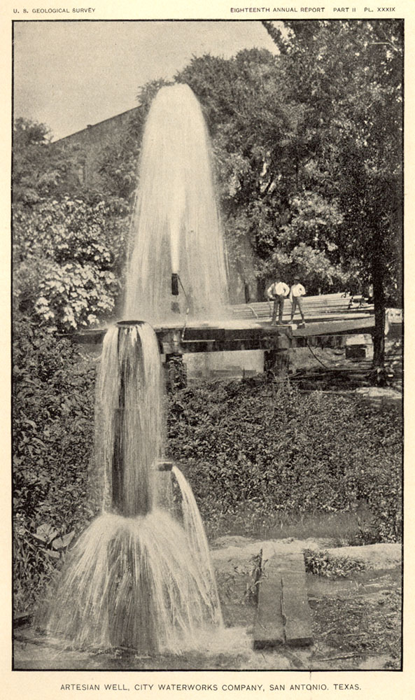
 |
Several of the remarkable Judson Brothers wells drilled for George Brackenridge at Market Street, site of the first large Edwards wells. There is still a major SAWS pump station at this location, and enough artesian pressure that most of the time pumping is not required. The image was published in Hill & Vaughn's 1896 report, in which they named the Edwards Aquifer and outlined how it works. The straight horizontal line in the upper left is not a hill, it is the old Casino Club building. The Casino Club was San Antonio's first social club and theater. It was started in 1854 by twenty Germans who gathered for conversation and sociability. It closed in 1923 and the building was demolished for construction of City Water Works offices. |
-
In 1849, some of the troops that had fought with William Jennings Worth in Mexico camped around springs in San Antonio during a cholera epidemic. Worth and 600 others died, and for a while the campsite of the troops was known as "Worth's Spring". There are least three different stories regarding the location of the campsite and springs, and it is not completely clear if the site was at San Pedro or San Antonio Springs.
In her well-researched history of San Pedro Springs Park, Cornelia A. Crook reported that after Worth's death, San Pedro Springs became known for a time as Worth Spring (Crook, 1967).
In an unpublished 1975 manuscript on the history of the Incarnate Word grounds, Betty Dunn reported that by 1852 the large spring on the property (presumably the Blue Hole at San Antonio Springs) was variously known as "Worth's Spring", the "North Springs", and "San Antonio Spring". All three names appear in an Abstract of Title prepared for the Incarnate Word Property in 1936 (Dunn, 1975).
In a 1973 newspaper article on the re-awakening of long dormant springs after heavy spring rains, Incarnate Word Information Director Dick McCracken told a reporter that Worth's Spring was located underneath Clement Hall, one of the dorms, and that water was being pumped out at a rate of 4,000 gallons per hour (Springs run again on grounds of IWC,
San Antonio Express-News, July 20, 1973).
In her 1989 report on the archaeology and early history of the area, Karen Stothert reported that many people believe Worth's Spring is the large spring located north of the east end of Olmos Dam (Stothert, 1989).
-
An archaeological survey by Anne Fox, in which she looked for 19th century military encampments in the Olmos Basin, did not turn up any evidence. Since Worth's time, the entire Basin has been substantially modified by farming and bulldozers, and superficial remains of a temporary camp could have easily been erased (Fox, 1979).
-
So the location of Worth's Spring remains a mystery!
-
I got interested in the Edwards Aquifer shortly after I came to San Antonio
in 1972. I started collecting reports and photographs and reading all
I could about it, and I always assumed I would write a book.
During
those years when I was collecting a lot of material, I was also sort of a computer geek. When the web was invented in the
early 90's, that was about the same time that all the Edwards issues were
really coming to a head. I decided I wanted to learn this new web
programming language and started fooling with html tags using a text
editor.
Meanwhile, since the Edwards was becoming such a hot issue, I
knew there was going to be a real need for untechnical, unbiased information, so that
the public could make informed decisions and choices. At that time, I
was doing consulting work for many of the regional water agencies, and I knew none of
them had the resources or wherewithal to put anything online. And even
if they did, I knew it would have your typical institutional bias, and that
sort of information doesn't always necessarily serve the public very well.
So
I decided I would put my burgeoning webmaster skills together with all my
Edwards resource material and hack together a web page. The first
version went online in early 1995.
Part of keeping the material
unbiased and unslanted has meant not accepting sponsorships or advertising.
I don't get anything from webmastering these pages except the satisfaction
of knowing they are widely regarded by educators, students, and interested
citizens as a reliable, unbiased resource. About 30,000 people visit
this site each month, each one viewing an average of about 12 pages, and I thank YOU for visiting!
-
When converting a site to be mobile-friendly, web designers will tell you the first thing you have to do is cut back some of the content. I'm not willing to do that. I'm perfectly happy for these pages to retain a retro-look and be the place where you go for the deep story on the Edwards and regional water resources and history.
-
|